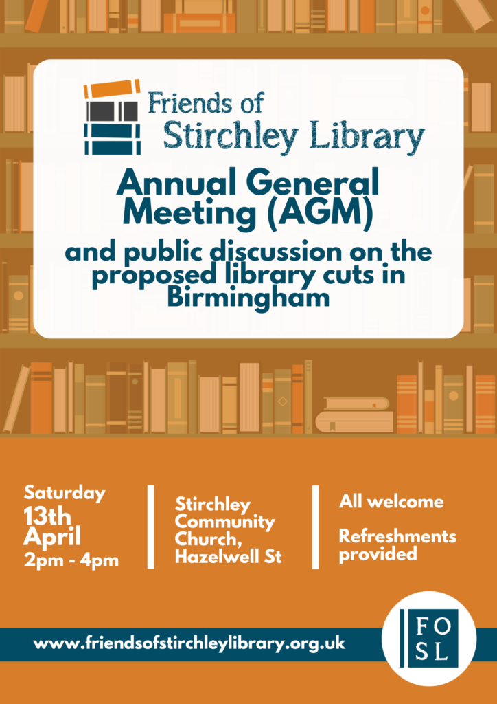
Traces of the Hazel Well and Hazelwell Mill

Hazelwell Mill was situated along the River Rea, near Hazelwell Park today. The photograph above is from Stirchley Library’s collection, and although undated was probably taken in about the 1930s. At this point, the mill buildings had expanded. The pool at the front is the millpool (like at the surviving Sarehole Mill), which was used to build up the flow of water and would then be let onto the waterwheel(s) when needed.

The area of Hazelwell was, from at least the 1300s but probably well before, owned by the Hazelwell family. Their name was probably taken from the area rather …

Continue Reading →

Plans for a New School

The year is 1876 and the architect Charles Wyatt Orford completes his plans for the new Strutely Street School. Edits were made the next year, and the school opened to 215 pupils in 1879. This replaced the older Strutley Street Branch National School which had opened in 1863, which Orford had also designed.[1]

The school has been altered and extended multiple times since, and I’m not sure how much, if any, of the original survives.

Attached to the school was the house for the teacher attached (see the parlour, kitchen and scullery in the plans, below, and three bedrooms on …

Continue Reading →

Stirchley School Photo Album

Captioned Stirchley St Infants 1924.

We’ll be adding a photo album of images related to Stirchley School here. If you have any photographs that you would like to add, please email: [email protected]

Captioned ‘Children’s Entertainment 1923’. Santa’s presence lets us know it’s Christmas!
Stirchley Juniors 1932. With courtesy of Pam Hobson. The boy circled is captioned as being Ken Russell on the back, aged 4, so that it is juniors is questioned. The teacher is captioned as being Miss Bristol.
Probably Miss Bristol, an early 1930s teacher.

Links

Continue Reading →

Which Field Do You Live In? And Stirchley’s First Brewery?

This wonderful map, above, was designed by Andy Underscore using the 1838 tithe maps for Stirchley (used with permission – see Andy’s original article here).

Stirchley was at this time part of Worcestershire, and part of the parish of Kings Norton, and Kings Heath, Cotteridge and Moseley were also part of Kings Norton parish. Stirchley also bordered with Northfield parish, and the border meandered along the same route as the Bourn Brook and then the Rea after the Bourn flowed into it. The tithe map named all the fields, pastures and meadows, which Andy transcribed. Stirchley Library is situated …

Continue Reading →

How Old is Stirchley?

The answer is that no-one really knows, but the earliest known mention of the area is on 1 May 1658. This was in an indenture written in ink on vellum and signed by three people, and with a red seal attached for each. In it, ‘Stretley Streete’ is noted.

The indenture was concerning a ‘garden, orchard and backside [yard at the back of the house] and one little close or meadow’ which was in the tenure of Katherine Compton, a spinster, but ownership of the land was changing (see below). This is definitely the right ‘area because ‘Stretley Streete’ was …

Continue Reading →